Tag Archives: miniSASS

Finally the Falls!

River Walk Banner Logo small

On Day 5 of the Catchment to Confluence Karkloof River Walk the team was thrilled to be joined by 2 fresh pairs of legs, Mbuso Khambule (new SAPPI Environmental Officer) and Mondli Goba (SAPPI Communications Officer), just in time to pass through some of the SAPPI Shafton plantation areas on the Karkloof floodplain.

pic 1

Team setting off. From Left: Nduduzo Khoza (EWT Eco-Ranger), Mondli Goba (Sappi), Mbuso Khambule (Sappi), Twané Clarke (Karkloof Conservancy), Ayanda Lipheyana (GroundTruth) and the photographer behind the camera is Sue Viljoen (WWF-SA)

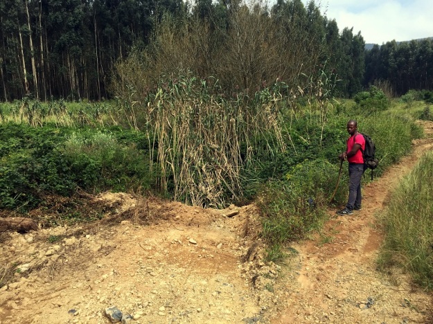
Our destination for the day was the Karkloof Falls, starting at the pumphouse on Gartmore farm, which as the crow flies did not seem all that far. But we now knew by experience that following the meanders of a river over rough terrain or tall vegetation where there is no path is not likely to be a walk in the park.

Pic 2

Sue Viljoen (WWF-SA) pushing through the tall vegetation in the wetland

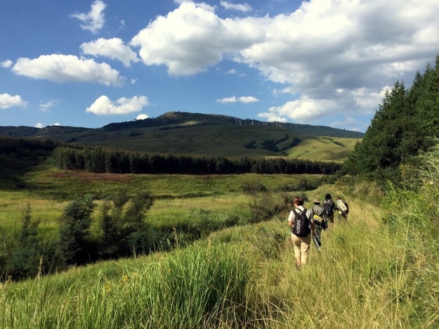
As we pushed through the wetland, we stopped to gaze at the distant Karkloof mountains, home to the river’s source where we had come from 5 days earlier, feeling pleased with the distance we had conquered so far.

We started up there

The team felt a sense of pride as we gazed upon the distant mountain

We were excited to see 2 Grey Crowned Cranes fly over us, with their characteristic “mahem” call, en route to one of the bird hides at the Karkloof Conservation Centre. What would Karkloof be without its treasured cranes? We had been treated to sightings of a number of cranes on the previous days as well. In total 11 Grey Crowned Cranes were seen and 4 Wattled Cranes. And it was only fitting that most of these cranes were spotted on farms belonging to “Crane Custodians”.

pic 3

Nduduzo Khoza (EWT Eco-Ranger) and Twané Clarke (Karkloof Conservancy) excited to see these custodianship signs.

Custodians are landowners who are formally recognised by the Endangered Wildlife Trust (EWT) for their voluntary contribution to the conservation of threatened species on their farms, such as crane, oribi or blue swallows. (Download “Guidelines for Custodianship in SA” here)

By tea time, we had traversed the Shafton wetland and reached the Karkloof River bridge which crosses over the road to Cramond.

pic 4

Karkloof River bridge along the Cramond road. From left: Ayanda Lipheyana (GroundTruth), Mbuso Khambule (Sappi), Twané Clarke (Karkloof Conservancy), Sue Viljoen (WWF-SA), Nduduzo Khoza (EWT Eco-Ranger) and Mondli Goba (Sappi)

Mbuso reminded us of the extent of SAPPI plantations that had been removed from the Shafton wetland a number of years ago and allowed to rehabilitate back to natural vegetation – some 186 ha were not replanted due to the existence of this important wetland system.

Pic 5

Looking back at the rehabilitated wetland beyond the bridge.

The next section of the river was slow moving, noticeably poorer in water quality and showed signs of being at the bottom of the valley’s catchment area, which ultimately receives all the nutrient rich runoff from the various activities along the way. The water colour had changed to a more murky greenish colour, there was a type of sludge on the rocks, in some quieter corners, traces of foam was seen on the surface and the sewage weed could be seen in many places along the river’s edge.

River Rockery Pano

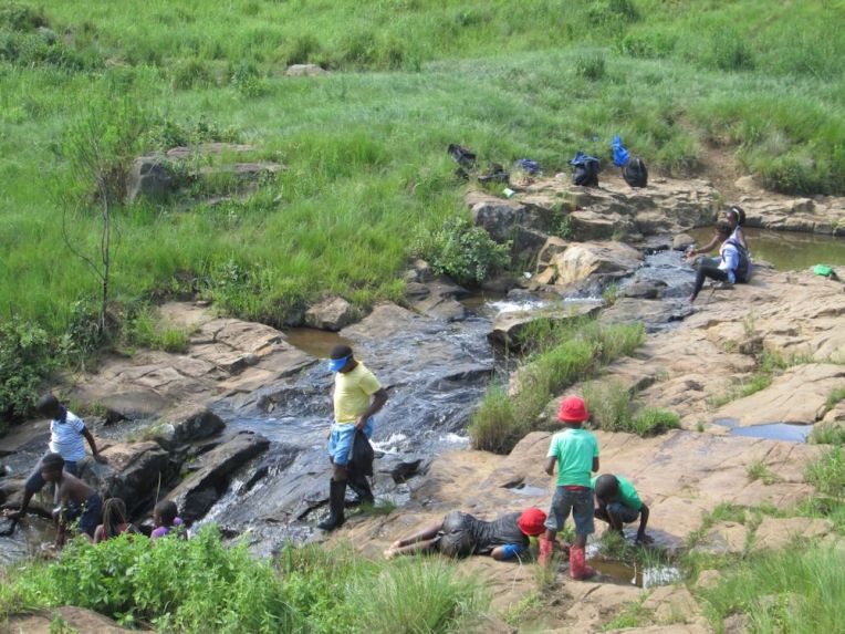
At the first set of large, impressive rocks above the falls, we did a Mini-SASS test, which showed the water was “critically modified”, confirming our impressions that the river’s quality was now compromised. At this site, a dead bushbuck was found between the large rocks, leaving us wondering what happened here. It looks like it lost its footing while trying to have a drink.

pic 6

Doing a miniSASS before heading off on the last section to the Karkloof Falls

The condition of riverine buffer along this last stretch was also compromised due to high levels of alien invasive vegetation (such as the big clump of bamboo shown below, poplar saplings, elderflower and all the other commonly seen invasives we had seen higher up in the catchment). Pastures were unfortunately established very close to the river, and therefore without a wide section of natural vegetation to act as buffer and filter for the runoff, the river is all the more impacted.

Pic 7

A clump of bamboo at the river’s edge.

Having followed every twist and turn of the river now for 5 days, we felt a certain sadness at the deterioration of the river’s health. However, the sight of the picnic site for the Karkloof falls picked up our spirits. Destination at last! Hooray for being able to pull off our boots and take a break in the shade! Here we were spoilt with orange ice-lollies by our videographer, Jayne Symes, who is putting a video clip together of the river walk. What a welcome gift! Thank you Jane!

Jane Symes

Jane Symes (Black & White Studios) was our hero that day. These ice cold treats were welcomed after a day of scorching heat and little shade.

While catching our breath over lunch, we chatted at length about the problem of litter at a public picnic site like this, and how increasingly popular the Karkloof Falls had become. Would new signage saying “litter free zone” and removing the dustbins help to change people’s behaviour so that all rubbish is taken away by visitors?

pic 8

Karkloof Falls picnic site along the river could be the perfect setting for a litter free zone

There was just 1 section left to walk down to the actual Karkloof falls viewing point and lower picnic site, our end point for the day. We said “bye for now” to the river, with the very last leg of the river’s journey to be continued the following Thursday, 6th April. A team photo in front of the falls was a fitting way to exclaim “WE MADE IT!”.

pic 9

We made it! The Karkloof River Walk team have reached the Karkloof falls

A Winding Watercourse

River Walk Banner Logo small

After difficult and long days, Day 4 promised to be less strenuous as the team were now truly in the Karkloof floodplain, where the terrain was more open and the river starts its characteristic meanders.

DSC_1889

With Sue Viljoen (WWF) unable to join us for day 4, Simon Bruton of GroundTruth stepped in as a substitute for the day.

DSCF1465_edit

Day 4’s river walk team. From left: Twané Clarke (Karkloof Conservancy), Simon Bruton (GroundTruth), Ayanda Lipheyana (GroundTruth), and Nduduzo Khoza (EWT Eco-Ranger)

Given the open terrain, by tea time we could see in the far distance the start of a line of trees, the end of which marked our finish point for the day. However, we knew there was still much walking ahead, given the many meanders, oxbow lakes and fences we would still need to navigate.

IMG_6090

On the floodplain cattle became a common sight, along with some of the impacts and risks they can introduce in proximity to watercourses. Eroded cattle crossings, drinking and feeding points (with associated cattle dung and trampling) contributed to water which showed gradual but increasing visual signs of change such as cloudiness, froth and abundant growth of nuisance vegetation, possibly thriving on an increased nutrient load. It will be interesting to see if the laboratory water quality analysis sponsored by Talbot & Talbot confirm the visual observations.

DSC_1944

Sewerage plant along with other signs of deteriorating water quality

Days 3 and 4 were the days of fence crossings. Given the fatigue setting in, humour was found in the different ways each of us may tackle a fence in the least strenuous manner, given our different loads and skills. Some would prefer to vault over and leave pack and kit intact, while others would disrobe all kit, squeeze through and kit up again.

DSC_1914

Ayanda negotiating yet another fence

Given the many meanders and fences, a tree trunk footbridge was a welcome but tricky crossing to negotiate.

DSC_1991

Negotiating the log bridge

Twané showing the muscle required of a river walker.

DSC_1926

After lunch we made a poor call on which side of the river to take, ultimately resulting in the need for a detour around a large mosaic of impenetrable wetland vegetation, which separated us from the river for some distance. Once re-united, water quality samples were again collected.

IMG_6016

At the tar road bridge over the Karkloof River, illegal and irresponsible dumping of waste tar material into the river was noted, posing a significant constriction to flow, and perhaps even affecting flood risk to the bridge, with one of the two culverts effectively barricaded.

DSC_2041

Waste tar material dumped off the Karkloof tar road bridge, introducing river impacts and potential flood risk

In the early afternoon Ouhout, Leucosidea sericea, was again found for the first time since the headwater sections. Numerous alien plants still made their presence felt (particularly bramble and bugweed), but not in the same densities that had been experienced on day 3. Having said that, some large isolated patches of bramble required some cautious retreat and detour.

DSC_2050

Nduduzo taking a water clarity reading at one of the last water quality sites of the day.

DSC_2059

As dusk approached and each camp fence was crossed, the team were joined by relays of inquisitive river walkers who call this beautiful area home.

DSC_2072

Bushwillows, Bushbuck and Bushwhacking

River Walk Banner Logo small

on Tuesday 28 March, as we reached our drop off point for day 3, courtesy of C. MacGillivray’s Karkloof Taxi Services, Sue Viljoen (WWF-SA) remarked that she was in need of a double espresso and a red bull. Yip, the typical day 3 stiffness had set in, and our bodies were yelling for more sleep and wondering why on earth we had volunteered to walk from dawn to dusk through some rather difficult terrain. Once we were on our way, with the morning mist rising and the river looking really beautiful, we soon forgot our morning blues.

IMG_6260

The Karkloof river, our source of inspiration

A hidden gem was waiting for us a few river bends later. Grassy river banks suddenly gave way to a small pocket of riverine forest and invited us in to explore. If we did not have at least another 10km to conquer that day, we would have loved to linger under that quiet, shady tree canopy created by some impressively tall forest trees, including Sue’s new favourite – The Forest Bushwillow (Combretum kraussii).

IMG_6259

Close-up of the Forest Bushwillow

We wondered how old this particular bushwillow was – maybe a good 50 to 90 years?

IMG_6258

Standing under the impressive Bushwillow

However the fantastical forest patches were soon forgotten when we saw the sad sight of green algae in a slow moving section of the river, a sure sign of nutrient enrichment.

IMG_6264

Green algae – a sign of nutrient enrichment

When we stopped at the next suitable place to take water quality samples, the mini-SASS result reflected a decline in river health.

IMG_5876

A sample to test for E. coli, nitrates and phosphates was definitely in order.

From this point on, the condition of the river bank vegetation also declined considerably with a proliferation of alien invasive vegetation, particularly bramble, which required frequent bushwhacking and made walking close to the river very difficult. We had to take a number of detours around or through plantations and lost sight of the river for a fair distance, often due to a hedge-like wall of bramble that separated us from the river.

IMG_6263

Wall of Bramble separating us from the river

We also came across 2 large areas of erosion on exposed, steep river banks.

IMG_6265

Riverbank erosion causes increased sediment deposit in rivers during rainy and stormy weather which leads to the silting up of rivers and dams.

While gazing at the extent of the erosion, a bushbuck suddenly bolted out and made a quick disappearance again. What a treat to see one of these shy antelope! Another boost to our spirits was coming across a few more forest patches with giant-size Bushwillows, Cape Chestnuts and Cabbage Trees.

Three noteworthy sightings from today can adequately be summed up as – The Good, The Bad and the Ugly.

IMG_5919

The Good – Beloved Bushwillows

IMG_6261

The Bad – Formosa Lilies (Lilium formosanum) an emerging weed, which despite its aesthetic appeal is spreading rampantly.

IMG_5953

The Ugly – Bulldozer activity, altering the river banks and clearing vegetation. Such disturbance is likely to attract more invasive weeds.

When we finally got back to the river’s edge and put some of the more difficult terrain behind us, we came to one of the five fixed sampling points where water quality and river flow is sampled weekly by GroundTruth. This is part of a river monitoring project for the Karkloof Irrigation Board, funded by WWF-SA, along the Karkloof and Kusane Rivers. We were encouraged to find a stonefly at this site, doing a fine display of “push-ups” for us, whereby it pushes its body up and down with its legs which is one of the distinguishing features of stoneflies compared to other aquatic invertebrates.

IMG_5993

Our “bodybuilder”, the Stonefly which was doing push-ups for us.

Seeing time fly by, we had to press on to try reach the pick up point before dusk. A new landscape lay before us of beef grazing peacefully on rolling hillsides, maize lands and lush dairy pastures. The change in land use was also coupled with a change in river characteristics, as the river flow slowed down over flatter floodplain terrain, and began to meander more and more.

IMG_6001

After a long day, seeing our trusty steed comes into view (a certain white Prado) was truly a welcome sight – and one which deserved a silly photo to celebrate!

IMG_5982

SAPPI Saunter

River Walk Banner Logo small

On Monday, 27 March the eager walkers were greeted with a clear sky for Day 2 of the Karkloof Catchment to Confluence River Walk. We were thrilled to have Hlengiwe Ndlovu, an environmentalist for Sappi, join us for the day and share her expertise and knowledge with our team for this vitally important project.

IMG_5830

Day 2 River Walkers. From Left: Sue Viljoen (WWF-SA), Hlengiwe Ndlovu (SAPPI), Twané Clarke (Karkloof Conservancy), Nduduzo Khoza (EWT) and Ayanda Lipheyana (GroundTruth)

The team were dropped off at the same point that we ended at on the previous day and started a new Riparian Health Audit (RHA) to measure the quality of the upcoming river stretch. A miniSASS study along with water chemistry tests were also conducted.

IMG_6257

Testing water clarity

The journey along this first RHA section yielded a “Fair” result, which had been the lowest score we’d gotten since the source of the Karkloof river. We anticipated that the results would show a decrease in river health, as we had come across the first sign of humans since starting on our walk.

IMG_5772

Signs of human life (a rare sight since Day 1’s walk)

Hlengiwe was enthusiastic about the River walk: “I think the project will provide valuable “point information” of where/what impacts occur along the river for the landowners to enable targeted action. It will also be worthy in providing positive feedback to landowners who’ve completed good rehabilitation interventions.

IMG_5825

Hlengiwe Ndlovu (SAPPI) was thrilled to walk along the Karkloof River with us.

This RHA area was badly infested with Wattle and Bramble; there were signs of litter and small scale dumping; and Ayanda Lipheyana of GroundTruth pointed out the “Sewerage plant” which grows along river banks where there is a high nutrient load in the water. This warranted a sample to be taken for E. coli, Nitrate and Phosphate tests to be done. These samples are sent daily to Talbot and Talbot who have kindly donated their time, equipment and expertise for this project.

IMG_5774

A portion of the Bramble infestation.

We soon entered Plantation territory, where the team were treated to interesting stories from Hlengiwe about the challenges they face when planning Invasive Alien Plant control within the plantation areas.

IMG_5787

This walk has inspired some valuable discussions while sharing thoughts and ideas.

The team were impressed with the progress that has been made by SAPPI in the stretch we were walking for the day.


IMG_5829

Appreciating the healthy looking riparian zone between the two plantations.

The riparian zones were looking healthy and we had an easy walk through the grasslands, appreciating the lack of bramble hooking onto our clothes and skin.

IMG_5806

The team enjoying a bramble-free walk

Hlengiwe pointed out the Bracken in a few areas, telling us about the nightmare in trying to control this pioneer species. This plant is a common sight in the KZN Midlands, turning a beautiful golden brown colour in the autumn. There was a consensus in the discussions between the team that the most effective way in controlling the spread of this plant is to keep it short and cut the regrowth at its early stages.

IMG_5826

Hlengiwe Ndlovu (SAPPI) pointing out the Bracken that proves difficult to remove.

As the team saw their homestretch to the end of day 2, Ayanda’s foot managed to find an animal’s home on the grassland slope, unfortunately twisting his ankle in the process. One of the dangers of walking through unpathed areas.

IMG_5824

Ayanda getting his ankle strapped by Nduduzo to help him reach our end point at the bridge in the background.

Hlengiwe commented: “I enjoyed being up close and personal to the river, which is a rare opportunity as one often sees the river in bits and pieces. I also enjoyed the anecdotal stories from the team of the different “river experiences” we’d all had and how we’ve all experienced the Karkloof thus far.

IMG_5828

A happy team at the end of Day 2. From left: Nduduzo Khoza (EWT), Ayanda Lipheyana (GroundTruth), Hlengiwe Ndlovu (SAPPI), Charlie MacGillivray (Karkloof Conservancy and our amazing backup, support and driver), Twané Clarke (Karkloof Conservancy), Sue Viljoen (WWF-SA)

Our sincere thanks to all sponsors and landowners who have made this walk and study possible. So far it has proven to be an extremely valuable exercise and we look forward to the rest of the journey.

Source Seeking and Catchment Clambering

River Walk Banner Logo small

Clamber (verb): to climb or move in an awkward and laborious manner, typically using both hands and feet.

This sums Day 1 up quite adequately, especially whilst we were trying to find the source of the Karkloof River! The source proved to be well hidden within a thicket of Ouhout, Leucosidea sericea, mixed with some other indigenous shrubs and trees such as the Nana-berry, Searsia dentata, and a few ferns and creepers.

Source team

The river walk team at the source of the Karkloof river

The river walkers were ready to start their intrepid journey of the first 10.6km of the Karkloof River at 7am, with a light misty drizzle – typical of the Midlands mistbelt. Our team comprised of Twané Clarke of the Karkloof Conservancy, Ayanda Lipheyana from GroundTruth who do routine water quality monitoring for the Karkloof Irrigation Board, Sue Viljoen of WWF-SA who have been working on a number of Water Stewardship initiatives in the Umngeni catchment, and Nduduzo Khoza an Eco-Ranger for the Endangered Wildlife Trust (EWT).

River walk team

Off we go… From left: Sue Viljoen (WWF-SA); Nduduzo Khoza (EWT); Ayanda Lipheyana (GroundTruth); and Twané Clarke (Karkloof Conservancy)

The team followed the stream until they reached a sight with sufficient water to begin the first set of water quality sampling techniques. These methods will be repeated down the length of the Karkloof river to build up a better picture of the river’s current status quo.

MiniSASS

MiniSASS – identifying the invertebrates to determine river health

Tests included a miniSASS (using aquatic invertebrates to determine river condition), a Riparian Health Audit (RHA) and taking water quality readings such as pH, clarity, dissolved oxygen and temperature. All results have been captured on smart devices using a new app called GeoODK, which GroundTruth have customised for river monitoring purposes.

IMG_5618

Testing the clarity of the water

Most miniSASS tests indicated good condition, with one site boasting near natural conditions. The highlight of the day was finding an elusive Stonefly at this site which is known to be the most sensitive invertebrate to river impacts.

stone fly

Yes folks, that little insect made our day!

The site that only had a fair condition was possibly indicating the impact of erosion, invasive alien vegetation and log jamming.

log jamming

An example of log jamming. Removing these obstacles in the river will make a world of difference.

We were all fascinated by the abundance of Ouhout growing  along drainage lines, gullies and riverine areas. We’re particularly interested to find out from the locals about the history of this area and whether these trees have always been here or if it has gotten denser through the years – ideas welcome.

Ouhout

Overall, we were quite surprised by the extent of the impacts so soon in the river’s journey. Wattle, Bramble and Blackjack are prevalent and will require large scale and carefully planned clearing, with assistance of other organisations, if the vision of an alien free Karkloof river is ever to be realised.

bush whacking

We were also treated to some of the most beautiful scenery,

Panoramic view

unique flowers,

purple flower

spoor of what we suspect to be a Brown Hyaena that we followed for a while,

Hyaena spoor

and lots of frogs.

Ndu Kisses a frog

As the sun began to set over the picturesque hills, we realised we were chasing the clock to reach our final point before dark. The flying ants glistened in the dusky light and the temperatures began to drop.

sunset flying ant photo

The team finally reached the end at 6:30 pm where we were warmly greeted by Charlie MacGillivray who is both a landowner and the Chairman of the Karkloof Conservancy. Let’s hope Day 2’s stretch of the Karkloof river is kinder to us.

Our sincere thanks to all landowners who gave us permission to walk on their properties today. We thoroughly enjoyed exploring your part of the Karkloof which set the tone for the rest of the journey.

Learning is Easier When it is Fun!

Everyone knows that you learn better when you are having fun. The Mpophomeni Conservation Group also know that there are plenty of opportunities for learning and fun right on their doorstop.  As the youngsters headed back to school last week, they had lots of stories to share about the variety of holiday activities organised by the Mpop Kidz Club facilitators Ayanda Lipheyana and Tutu Zuma.

Whenever they suggest a fieldtrip to explore the uMthinzima Stream to do some miniSASS and turbidity tests, a small crowd of enthusiastic youngsters interested in acquiring more knowledge about the environment, arrives.

mpop streams mini sass 045

Early in December the younger members of the club learned about river health and the water creatures that indicate good quality water. They headed to the uMthinzima stream for a practical session. There was a manhole spilling into the river, so it was too dangerous to get in the water to do a miniSASS, but they did test the water clarity – it was only 3cm!

We talked about how a miniSASS test works and practiced pronouncing all the difficult words. Samke, in Grade 3 was curious “Why don’t we take frogs and fishes into consideration when doing miniSASS?” she asked. Noxolo, in Grade 7 explained that we only use aquatic invertebrates for the survey because they are easy to catch. “Sisebenza ngezilwanyana ezingenawo umgogodla.”

terra madre mini sass 056

A few days later, a group returned to do some proper mini SASS tests working their way up the stream from the very polluted area behind the Municipal Offices. It was lovely warm day and although it started to rain before we were finished, everyone enjoyed themselves.

mpop kidz walk along uMthinzima stream

At the first site they found worms, crabs, bugs and damselflies- a dismal score of 4.25. Further upstream the score improved to 5.2.

mpop streams mini sass 005

As we walked, we passed small forest patches and the children took the opportunity to discuss alien plants and indigenous forest.

mpop streams mini sass 021

At the third site we found mayflies, damselflies, bugs or beetle and caddisflies. There were lot of stones and fast flowing bubbling water – the stream was largely natural – in a Good condition.

mpop streams mini sass 049

At site four we found flatworm, crabs, other mayflies, damselflies, dragonflies, caddis flies and true flies, but the score dropped to 6.5.The water clarity test was 64.

mpop kidz umthinzima stream mini sass

Exploring Nguga Stream

A small group of high school kids trekked across to the Nguga Stream on Goble’s Farm opposite Mpophomeni just before Christmas. During the morning, four children who live nearby were watching us and we called them to join in.mpop streams mini sass 104

The first spot we did a miniSASS test was just below Midmar Crushers. We found flatworms, Minnow mayflies, Damselflies and true flies – a score of only score of 3.5. The turbidity score was high – 50cm. There was a short discussion about what could be the reason for a low MinSASS average score when the water clarity was good? Ayanda explained “The MiniSASS average score shows that the site is in very poor condition and the water clarity score shows that the river condition is not that bad. Better water clarity does not mean water is in natural condition. If we can do MiniSASS in water that we drink from the tap. We will find no insect and the MiniSASS score will be zero while the water clarity is 100cm.” Asanda thought it was possible that at Midmar Crushers release some chemicals in the stream that kills insects but does not affect water clarity.

mpop streams mini sass 145

Our next site was 100m downstream from the first. The MiniSASS average score improved to 4.25, but the water clarity test decreased from 50cm to 31cm. We noticed that between site1 and site 2 people were washing, children were swimming and cattle passing through the stream.mpop streams mini sass 147

Another 200m downstream we did another water clarity test and we got only 17cm! The site is spot where the surrounding community dump their rubbish. The manager of the area, Doug who joined us, said people are dumping rubbish in the stream because the Municipality does not collect rubbish for Nguga community. He suggested we start a petition and forward it to the counsellors or municipality authorities.

mpop streams mini sass 125

As we walked we saw 2 dead goats in the stream and a leaking manhole. However, the sewage does not go straight into the stream, it spreads over the land and has formed a ‘sewage wetland’ near the stream. The MiniSASS test we conducted here was 3.8 and the water clarity has improved to 31cm We thought that the leaking manhole was not affecting the stream that much.mpop Nguga stream stream mini sass

Everyone enjoyed exploring a new stream and had fun making things from the clay on the banks.

mpop streams mini sass 123

Exploring Nguga Forest

Early in January the MCG trailed across to the forested area near Nguga stream to learn about trees.

mpop january 090

In groups they identified 12 indigenous species and discussed the functions of each tree using the Sharenet Forest Community Handbook.

mpop january 070

They repeated the exercise in a plantation nearby and found only five species.

mpop january 047

They surprised a group of kids swimming in the stream! Eish, it was HOT!

kids swimming in nguga

Learners were given the pictures of a puzzle of environmental issues around rivers that they had to fix.  They gave feedback on what is wrong and how they did fix it.

mpop january 081

Nomfundo Mlotshwa said “I enjoyed myself today, it was great. I learned a lot of new things about gum trees and that there are many different species in an indigenous forest. In the indigenous forest there is more shade and the plants that grow there help one another to survive.”

mpop january 071

From the forest to the grassland – our next outing was up the hills that surround Mpophomeni to conduct a grassland study. We wanted to compare the grasses at the top of the hill and at the bottom. We were hoping to find more species at the top.

As we walked, participants remembered other times they had been up the hills. Bulelani Ngobese remembered that way back in 2009 he left his red cap on top while having a picnic and wondered if he would find it again!

mpop kidz jan 036

On top each group collected different species of grasses within a 9 metre square area for 15 minutes, then spent time identifying the different species using the Grasses of SA guide.

mpop kidz jan 014

We found 15 species of grasses but couldn’t identify all the species. We did identify thatching grass, red grass, brown needle grass, bristle grass and spear grass and discusses the functions of grasses and whether or not each species was palatable to cattle.

mpop kidz jan 042

We had a picnic of apples, eggs and fresh, cold water before heading back down the hill. At the bottom in the disturbed area we only managed to find 7 species of grass.

mpop kidz jan 037

Everyone really enjoyed the excursion. Phelelani Sibiya said “Sihambile kakhulu safunda.Sahlukanisa izinhlobo zotshani esizitholile saphinde sadla sasutha saqeda sahamba.” Tharibo Zondi added “Osukwini lanamhlanje sifunde lukhulu bengingazi ukuthi utshani buhlekene,sengizokwazi ukufundisa abanye abantu uma sibambisane singenza okugcono.”

We were all happy to conclude that our assumption was correct – we did find more species at the top of the mountain than at the bottom of the mountain.

mpop kidz jan 008

Tutu commented “The views were amazing, most of the kids had never been up here before. they could not believe how beautiful Mpophomeni looks from so high up.”

Children from Ethembeni Family Centre are keen to adopt part of the uMthinzima stream that is only 50m away, to keep the banks free of litter and monitor the condition of the water. The purpose of this excursion was to introduce the 22 kids and 4 adults to mini SASS.

mpop kidz jan 147

We walked from Mpophomeni Library to uMthunzima stream behind the Municipality offices near the sewage pumping station to do the first test. We found flatworm, redworm, damselflies, bugs, beetles and snails, the river is in very poor condition. The water clarity was only 9.00cm.

mpop kidz jan 138

It took about an hour to walk to the second site. Along the way we saw some indigenous trees. 10 year old, Anele Mgadi said”Ngiyasikhumbula lesi sihlahla umama wethu uSofe usake waifundisa ngaso e-centre.”   Then she thought for a while and said “umlahlankosi usetshenziselwa amadlozi.” Ziziphus mucronata or Buffalo Thorn.

mpop kidz jan 129

At the second site young John observed that the river condition was improving. We found caddisflies, true flies, damselfies, other mayflies, damselfies, minor mayflies, crabs and flatworm and our score was 5.7. The water clarity was 35cm

mpop kidz jan 082

The kids made notes about all that the found –

We should make sure that we keep the manholes clean so that we can drink clean water. We found a leaking stamkoko 3 years siqalile so that means 3 years makaka engena emanzini! We do not to have throw rubbish in the river, we can make many things with rubbish by recycling. We found some stones, we found some small insect living under small stones. Sabona isitamukoko sokugcina esingena emanzini uma ufuna ubhukuda. Bhukuda ngenhla kwaso not ngenzansi.

mpop kidz jan 081

We walked along the banks for another two hours passing some children swimming. In the clean clear water Nhlaka found a stonefly! “Look what I found. I found a big one.” He shouted, with no idea how exciting his find was. Our miniSASS score here was 9.

mpop kidz jan 059

Ayanda concludes “This was the one of best young groups I have had so far. They were all active and participating. We all had fine time and experienced new things together.”

For the very last excursion of the holidays, the kids asked if they could walk along the uMthinzima again to the top where the water is clean. 38 youngsters aged 8 to 19 and four adults joined in the river walk! They will be monitoring the stream at once a month and conducting regular clean-ups along the banks of the stream.

mpop kidz jan 108As expected, the river behind Municipal offices near the sewage pumping station gave us a very low score of 3.8. The water clarity was 6cm.

mpop kidz jan 192

We walked for the next three hours, not dawdling too much as the kids were keen to swim in the clean water at the top. We passed some other kids swimming along the way.

mpop kidz jan 079

Near the source of the stream, where it is natural condition, we found crabs, flatworm, snail, dragonfly, other mayflies, damselfly, bugs and beetle and caddisflies – a super score of 8. The water clarity was an amazing 97cm – what a difference from only 6cm further down! Everyone was happy to see clean water in uMthunzima stream and had fun exploring and splashing.mpop kidz jan 185

We explored the forested area on each side of the stream. It was lovely and cool.

mpop kidz jan 173

To conclude the day we used a picture building game. On one side the river is polluted while on the other side was in natural condition. All the kids were given different coloured crabs. Red crab (no life or poor condition), green crab (natural condition), purple crab (poor condition) and had to put the crabs into the poster where they think they belong.

Nosipho Mchunu, in Grade 6 loved the walk. “I have never been up here before, it was so beautiful, I loved it.”

mpop kidz jan 170

Tutu Zuma, MCG facilitator “We had a great day and hopefully the kids did learn new things.”

Now that’s a lot of lekker, local holiday activities! Thank you N3TC for supporting the Mpop Kidz Club.

uMthunzima miniSASS Surprise

Last month, the Mpophomeni Conservation Group invited youngsters to learn about the indigenous forest patches in the area and compare them to man made plantations. Discussions amongst the students around the issues of Alien vs Indigenous were vigorous. Nomfundo Mlotshwa was curious to know why people still planted invasive species which use so much water.  “To make all the furniture – like our school desks.  iHlahla zesizulu zikhula zibe nestem esincane. Indigenous trees grow too slow.” Asanda Ngubane replied.

mpop mini sass 013

They wandered up the valley along the stream in search of interesting trees, and to their horror, observed five overflowing manholes polluting the river and six dumping sites close to the bank. “I am worried that the rubbish will wash into the river when it rains” said Lineth Mbambo.

mpop mini sass 071

Much of the river that they walked beside appeared to be in a very poor condition.

mpop mini sass 033

Once they got beyond the mass of houses, they were pleased to discover the river in a much better state. They explored a little and determined right away to return and do miniSASS tests along the length of the uMthunzima which flows directly into Midmar.

mpop mini sass 042

Then a couple of weeks ago, ten enthusiastic learners turned up on a cold and rainy day to explore more. Ayanda Lipheyana (MCG facilitator) helped them make raincoats out of refuse bags to ward of the worst of the wet. They did four miniSASS tests in four different sites. Ayanda reports:

mpop mini sass 145

We named our sites 1, 2, 3 and 4. Before we started Sihle Ngcobo asked “What is miniSASS? I saw the word in your invitation SMS and went to the dictionary but unfortunately I didn’t get the definition.”  I explained  what it is and why it is important to monitor streams in order to understand changes to the stream.

At Sites 2 and 3 we did miniSASS together. Kids were separated into 2 groups to do miniSASS at site 1 and 4.  Site 1 is lower down the stream and site 4 is up the uMthunzima stream closest to the source. As we go up the stream kids noticed that the clarity of water improved and miniSASS score changed from bad to good.

mpop mini sass 147

At site 1 the water clarity was good but the miniSASS score was 3.5 which is very bad. We thought it because there was not too much life. We only 4 invertebrates and there was no oxygen because water was moving slowly and there is raw sewage from the manhole entering the stream above.

mpop mini sass 155

At site 2 the water clarity was good and the miniSASS score was better – 5.6. There was more life and no sewage coming into the stream but there was some human activities – like washing and an illegal dumping site.

mpop mini sass 164

At site 3 the water clarity was very good. There was more life we found 5 invertebrates and score was 7.8 which means the river is in good condition.The water was bubbling over the stones, which meant there was oxygen in the water.  Here Asanda Ngubane found a stonefly!

Kids were so excited to see a stonefly for the first time. Philani Ngcobo said “I did not know about the stonefly.  I was so happy that I learnt something new, and that part of our river is clean and good for the animals that live there.”

mpop mini sass 152

At site 4 the water clarity was the same as at the site 3 but the miniSASS score was only 5.6. We found 7 invertebrates. Water moving slowly, means low oxygen.  We are confused why we got so much difference between site 3 and site 4 because site 3 and 4 they are 15 meters away from each other and site 4 is further upstream than site 3.  We will return to these sites again.

We had fun and the kids plan to go back on a sunny day, do more test and compare results. Londeka said “It is a new information for us about aquatic invertebrates adaptations and it will help us in Life Science.”  I made it clear that we can only drink water from the stream where we found a stonefly and that if there are human activities upstream we can not drink that water.

mpop mini sass 029

Earlier in October, MCG collected 46 bags of litter from the uMlanga Stream near where it flows under Mandela Drive. Ayanda phoned the Municipality to collect the rubbish and was pleased when they arrived a few hours later. Ayanda concludes: We chose this spot because it is visible. to encourage others who love their environment to volunteer to help.  People passing by appreciated the work we were doing.  One said “We must make you guys counsellors because it seems you love your area”.

46 bags collected clean up

Gomfidae in Mpofana – Yay!

Brave Balgowan Conservancy hosted a Water Workshop just as the water was starting to get chilly.  This is part of the MCF Protecting Ecological Resources Project funded by N3TC. Priscilla Young wrote this report:

Penny Rees gave us a super talk with video footage of her walk from the source of the uMngeni river to the sea.  Then we then went down to the Dormer Bridge where we went wading into the Mpofana River.  Here we look up streammpofana from dormer bridge

Penny said this was going to be the perfect spot for us to do our testing and collection of species. We are now “Entomologists of the Aquatic kind”! However, this was not a pretty place on the river.

pollution mpofana

We found a nice flat rock to sit on and scrutinise what we found,  lots of rocks and slow and fast moving water – the ideal spot for a miniSASS test.

mpofana 1

Time to get the feet wet – Yvonne, Nhlaka and Penny start ‘fishing’

mpofana feet wet

Nhlaka has caught a “tub” full of “goodies”

nhlakaAnd David too!

david crowePenny, Yvonne and Nhlaka sifting and identifying their catches with magnifying glass to get a closer look.

yvonne nhlaka penny 1All the Yoghurt pots have been emptied onto the platter for examination by the “catchers” and listed by Penny. All sorts of interesting little water creatures were discovered – ready to be photographed and catalogued.

mpofane photo

This fellow was our major find! Apparently quite difficult to catch and find, and I believe the Dargle Conservancy will be quite jealous of this chap! This is his grand name! Dragonfly: Gomphidae Mini SASS Score: 8.25: Natural, unmodified condition. Penny commented“Howzat?! Not often we find such a good score.”

gomphidae

What a fruitful day. The weather was fantastic and Penny came to the conclusion that at this point – The Dormer Bridge – the Mpofana River was really very clean BUT we now wait to see what happens further upstream and when the Spring Grove Dam comes fully into operation.

Penny adds: The Mpofana is a crucial part of the Mooi uMngeni inter-basin transfer as the water from the Mooi River is deposited into this stream. This is already causing erosion, so everyone is waiting with bated breath to see what happens when the increased amount of water is sent down from the new Spring Grove Dam.

This is a list of what was caught/found in the River and we now have to monitor on a regular basis. Hopefully more people will join us in the next in the Water Workshop. It really was a lot of fun!

  • Flat worms: Planaria
  • Fresh water shrimp
  • Stonefly: Perlidae
  • Minnow Mayfly: Baetidae
  • Other Mayfly: Heptagenidae, Tricorythidae
  • Dragonfly: Gomphidae
  • Bugs / Beetles: Gyrinidae, Veliidae
  • Snails: Ancylidae

Penny Rees and her team of DUCT River Walkers will be exploring the entire Mpofana River in October this year.  Read her version of the day’s events.

mpofana water workshop

Winterskloof Gets Wet

Autumn is in the air.  We gathered on a beautiful, sunny, ‘freshly washed’ Sunday morning recently to enjoy the first of the Winterskloof Conservancy Water Workshop series.

DSC_0272

Judy Bell writes:

Penny Rees of DUCT (Duzi-uMngeni Conservation Trust) and Mngeni River Source to Sea Walk fame began the workshop at Cowan House with a discussion about the need to look after our catchments in KwaZulu-Natal.

Our Valley is the watershed for the Dorpspruit, which feeds into the Msunduzi and then into the uMngeni River.  As you can see in the diagram below, the sources of about 12 streams are located right here in our Valley (shaded area) and our properties.  Hence the importance of us all becoming river custodians.

dorpsruit tributaries

Conservancies and communities along the uMgeni River and various catchments are forming partnerships with DUCT to assist in monitoring and protecting the rivers and their catchments in an effort to release more water of good quality into the system.  These workshops held in the Midlands Conservancies are educating communities to monitor rivers in a practical and easy way, so that we can all take action to improve the situation.  A grant from the N3 Toll Concession (N3TC) to the Midlands Conservancies Forum has enabled Penny Rees to run these workshops for the 14 Conservancies that make up the Forum.

The more people who learn to do these easy river health assessments, the more monitoring results will be available for the streams flowing through our properties and neighbourhood.  If we continue to record the results, we will be able to trend the quality with time.

IMG_6718

Penny explained some fast-flowing facts about our water:

  • The uMngeni River arises in the uMngeni Vlei (Nottingham Road area) and flows to Midmar Dam (our drinking water supply) through intensively farmed areas – mainly dairy and pigs, with pollution from fertilizers, effluents and manure slurries, discharging into it.  It is also affected by raw sewage from blocked sewers, especially from the Mthinzima Stream, a tributary arising from the hills above Mpophomeni and flowing into Midmar.  Below the Dam, the river becomes heavily polluted in places as it flows through Howick, affected by contaminated stormwater, litter, raw and treated sewage.  The effluent from the Howick Wastewater Treatment Works flows over the edge of the krantz before the Howick Falls, into the Umgeni Nature Reserve.
  • The river is infested in many places with invasive alien plants such as bramble, bugweed, black wattle (Acacia mearnisii).  This is an invasive native to Australia, which grows unchecked in thickets, with no undergrowth to protect the bare soil, which then erodes easily.  The river previously meandered through grasslands, but with shading by the invasive wattle trees has changed the temperature and pH of the water, which encourages the growth of unhealthy micro-organisms and other plant life, affecting the river’s health.
  • Soil erosion, litter from illegal dumping and storm water drains, treated and untreated effluent all contribute to the deterioration in the health of the river as it makes its way to the sea.
  • Over one thousand million litres of water are abstracted from the uMngeni daily for domestic, agricultural and industrial consumption.  This is not sufficient to meet the increasing demand, which has led to the development of the Spring Grove Dam and Mearns Weir projects in the Midlands, transferring water from the Mooi to the uMngeni River.
  • Water is pumped at great cost from one catchment to another (e.g. Thukela-Vaal) to augment supplies.
  • Only appropriate developments should be allowed near sensitive wetlands and grasslands, which are often viewed as ‘idle land’, when in fact they are performing a life-saving role as water factories and cleaning agents.
  • eThekwini Municipality is currently spending around R1 million each month to clean uMngeni Water to drinking water quality standards and is now working with Msunduzi and uMgungungdlovu Municipalities to invest in the ecological or natural infrastructure that will help increase flows of good quality water into our dams – the wetlands, grasslands, forests in the upper catchments.  This is why the Midlands, with its ‘water factories’, is so important.
  • The River Walks that DUCT undertakes has shown that rivers can ‘heal’ themselves if there is sufficient space between the damaged areas (pollution and invasive alien plant infestations).   In the Cumberland Nature Reserve, this was shown to be a 10 km stretch without pollution, development or alien plant infestations.
  • Monitoring and knowledge of the health of rivers has become a priority, which is why the miniSASS river health assessments (Stream Assessment Scoring System) were introduced, to help citizens join the programme and learn about the water quality in their communities.

Water Quality Monitoring – No High-Tech Equipment needed!

The beauty of this testing system lies in its simplicity.  Anyone can learn how to collect a miniSASS sample on a river or stream, and determine the water quality and health of water resource.  It involves catching and identifying the number and types of macro-invertebrates (small animals) or “nunus” which live in the water.  These are barometers (indicators) of the general river health and water quality. Equipment consists of enthusiastic samplers of all ages using various plastic containers (yoghurt or margarine tubs) with mosquito gauze on top, children’s beach fishing nets and pot plant drip trays for the catch, as well as the miniSASS score card and invertebrate identification booklet.

Sampling the stream 16Mar2014

The group moved down to the Doreen Clark Nature Reserve, just below St Michael’s Road to do a miniSASS on the stream flowing through the reserve.  This stream flows throughout the year through the mist-belt forest, but picks up the run-off from the road and houses upstream, so is not expected to be in “pristine” state.  Under Penny’s guidance, the group quickly collected specimens from the stream amidst lots of ‘oohs, ahhs’ and muddied feet.

IMG_6720

The “catch” was compared with the photographs and placed into groups.  The scores allocated to the different types of organisms was tallied and then divided by the number of groups to which they belonged.  Some organisms carried a higher score, as they are only present in “clean” water.  The stream scored 6.8 which is a rating of fair to good on the miniSASS scale (see Scoring Box below).

winterskloof mini sass score

We hope to involve the schools in the area to develop custodianship of the rivers and streams, to help with regular monitoring of the Valley’s streams’ health and water quality.  The website sass.orasecom.org has further details on testing, identification of the nunus, scoring and registration of the stream as well as a map, geographic coordinates and locations of the river or stream and how to submit test results which should be carried out with a minimum of 6 week intervals to allow the sample site to recover.

DSC_0335

Penny said she thoroughly enjoyed herself and that it was great to see how the younger members got so involved!

SASS – Ecological Category (Condition) Interpretation Score

  • Unmodified (NATURAL)                                                >7.9
  • Largely natural / few modifications (GOOD)       6.8 – 7.9
  • Moderately modified (FAIR condition)                  6.1- 6.8
  • Largely modified (POOR condition)                            5.1 – 6.1
  • Seriously / critically modified (VERY POOR condition)    <5.1

Thanks to all those who joined us for the Workshop, to Cowan House for hosting us, Penny Rees for enlightening us, the Midlands Conservancies Forum and N3TC for funding the Workshop and for those who joined us.  Winterskloof will have another water workshop later in the year in Spring, so watch out for this.  Balgowan Conservancy will host one on 27 April in the Mpofana River.

For more information, check out the DUCT uMngeni River Walk miniSASS and miniSASS websites.

IMG_6719

Splashing in Dargle on a Summer’s Day

Saturday 8th March dawned a glorious, sunny day as Penny Rees headed out to one of her  favourite places in the Dargle – the Dargle River on Howard Long’s farm Craigdarroch.

r Dargle River Workshop penny rees

This spot was chosen for the MCF/Dargle Conservancy Water Workshop because it is one of the few parts of the Dargle River which are in good condition.

Water Workshop 017

Penny reports: After tea and scones made by Howard’s wife Cheryl and daughter Jennifer, I showed everyone a slide show on the Dargle river walk which took place in January this year.  There was lots of discussion about how to clear invasive plants in the riparian zone and ideas and experiences were shared.

Dargle River Workshop 001

We then headed out to the river, passing spectacularly large bulls, who gazed at us from a shady spot, and hearing about the history of the farm.

Dargle River Workshop 017

The old stone storage shed that had been built by the original Scottish settlers (the Sinclairs) to double up as a fort if the need should arise.

Water Workshop 003

Above a cascade, Howard pointed out a large sheet of flat rock that was the ford (in the old days) – the only access to the farm! This must have been either terrifying or non-negotiable during heavy river flows!

Dargle River Workshop 025

Howard told us how they drank the water from this Dargle stream until about 10 years ago. He has been clearing wattles and other invasive plants along the tributary gullies which feed into the stream for many years.

Water Workshop 008

“Once you take out the wattles, the indigenous vegetation comes back. It is a 100 times better than it was, but obviously, each year you have to keep going back and clearing.”

Dargle River Workshop 067

“This river is only 18kms long,” he added “Surely, if we work together we can restore it to it’s natural state?”  Wyndham Robartes shared his experience of successfully clearing the riparian zones on his property using goats rather than chemicals.

Water Workshop 019

We crested a hill and there lay the Dargle River, clear bright water bubbling over rocks passing beautiful river banks with long waving veld grass that alternated with patches of forest.

Water Workshop 006

Penny explained how to do a miniSASS and armed with plastic containers, we were rearing to go.

Dargle River Workshop 048

Getting our feet wet was an absolute pleasure as we hunted for the invertebrates in the river – we found stout crawlers, prongills and damselflies and plenty more.

Dargle River Workshop 064

Once again (as during the River Walk in January) we hit the jackpot – Stonefly.

Water Workshop 015

The mini sass score for the days was 7.1  indicating that the river was in good condition.

Dargle River Workshop 083

A lively discussion followed on the roles that the different invertebrates have in the river ecology – from the slow moving planaria that favour shaded quiet waters to the frenetic riffle beetles that rush around on the surface of the fast flowing water.

Dargle River Workshop 076

Rose Downard found the morning  really interesting.  “Quite amazing what a difference it can make to the miniSASS score to find a Stone Fly, yet every insect has a part to play, including the humble snail. I think it would be wonderful if the whole of the Dargle River could be cleared of alien vegetation and restored to a healthy river again. It is an important part of the Dargle and should be treated as such.”

Dargle River Workshop 029